Human Interest
199.0K views | +4 today
Follow
Human Interest
Your new post is loading...
Scooped by Skuuppilehdet
Scoop.it!

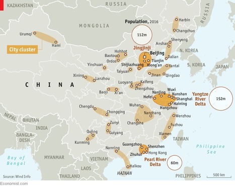
China is trying to turn itself into a country of 19 super-regions

China is trying to turn itself into a country of 19 super-regions | Human Interest | Scoop.it

"China's urbanization is a marvel. The population of its cities has quintupled over the past 40 years, reaching 813m. By 2030 roughly one in five of the world’s city-dwellers will be Chinese. But this mushrooming is not without its flaws. Restraining pell-mell urbanization may sound like a good thing, but it worries the government’s economists, since bigger cities are associated with higher productivity and faster economic growth. Hence a new plan to remake the country’s map.


No comment yet.
Rescooped by Skuuppilehdet from HOMEHISTORY
Scoop.it!

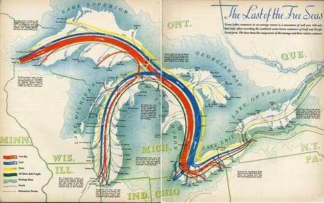
"The Last of the Free Seas"

"The Last of the Free Seas" | Human Interest | Scoop.it

"The Last of the Free Seas is the title of this fantastic map of the Great Lakes made by Boris Artzbasheff.  It was published in Fortune Magazine in July 1940."


Via Ben Salve
PIRatE Lab's curator insight, August 8, 2017 9:08 PM
Share your insight
Scooped by Skuuppilehdet
Scoop.it!

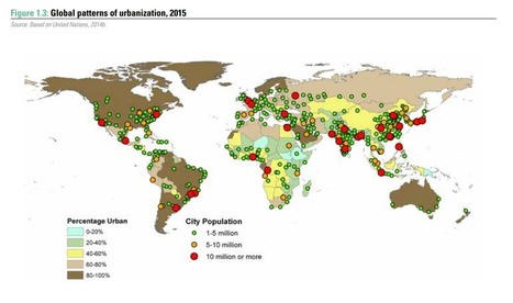
The Incredible growth of megacities

The Incredible growth of megacities | Human Interest | Scoop.it

"The world’s cities are booming and their growth is changing the face of the planet. Around 77 million people are moving from rural to urban areas each year. The latest UN World Cities Report has found that the number of “megacities” – those with more than 10 million people – has more than doubled over the past two decades, from 14 in 1995 to 29 in 2016. And whereas the developed world was once the home of the biggest cities, this map shows that it is now the developing world taking the lead."


Tags: urban, megacities, regions.

Carson Dean Williamson's curator insight, May 11, 2017 10:43 AM
This relates to our chapter by showing some facts on mega cities. Mega cities are metropolitan areas that have a high population. These cities are the definition of urban development around the world. There is currently 29 mega cities (since 2016) around the world. This article showed the growth of mega cities and urban development of the city.
Courtney Barrowman's curator insight, May 19, 2017 10:25 AM
unit 7
Melih Pekyatirmaci's curator insight, May 20, 2017 7:31 PM
Share your insight
Scooped by Skuuppilehdet
Scoop.it!

This map shows the US really has 11 separate 'nations' with entirely different cultures

This map shows the US really has 11 separate 'nations' with entirely different cultures | Human Interest | Scoop.it
"The political parties come and go but the values of the regional cultures are always at play."
No comment yet.
Scooped by Skuuppilehdet
Scoop.it!

Combatting FGM

"The United Nations Development Programme started to advocate against the practice of female genital mutilation (FGM) back in 2003 when it was taboo even to speak about it. In 2008, the practice was banned. The government of Egypt has institutionalized the adoption of FGM abandonment; while prevalence rates remain high (namely among older women), the response of younger girls and mothers of new generations to FGM abandonment campaigns is much higher."

Nicole Canova's curator insight, March 24, 2018 9:49 PM
Female genital mutilation (FGM) is a cultural practice that is or has been instituted in many countries around the world, predominantly throughout Africa and Asia.  Since the United Nations Development Programme started campaigning to end the practice in 2003, rates of FGM have dropped throughout the world.  Although it is too late for many older women, younger women and girls have received information about the harmful effects of FGM, and through them cultural attitudes toward the practice are shifting; because of that, millions of girls for generations to come may be spared from becoming victims of FGM.
Rescooped by Skuuppilehdet from Stage 5 Changing Places
Scoop.it!

Nine Nations of North America, 30 Years Later

Nine Nations of North America, 30 Years Later | Human Interest | Scoop.it

"Back in the ’70s, almost a hundred reporters around the country – Washington Post bureau chiefs, rovers, freelancers and me, their desk-bound editor – were trying to get our arms around how North America worked, really. Not how it should work. But how it did work. Forget those nice neat rectangles in the middle of the U.S. Let’s be real: The mountains of western Colorado are totally alien from the wheat fields of eastern Colorado. And Miami is part not of Florida, but its own watery Caribbean realm. And what a terrible idea is 'California.' It behaves as if it covers three warring civilizations. The result was my 1981 book, 'The Nine Nations of North America.' The reader reaction was astonishing. This map – drawn to anticipate the news – revealed something much deeper. It turned out to be a map of culture and values, which have nothing to do with our perversely drawn state and national boundaries."


Via GTANSW & ACT
GTANSW & ACT's curator insight, December 17, 2016 11:56 PM

An interesting look at settlement patterns in the USA if using this to compare with spatial patterns in Australia. A deeper examination will reveal reasons for differences in settlement patterns between the two nations. 


Syllabus

Students investigate differences in urban settlement patterns between Australia and another country, for example: 

  • examination of urban settlements to determine patterns of concentration 
  • explanation of factors influencing urban concentration eg climate and topography, transportation networks, land use or perceptions of liveability
  • assessment of the consequences of urban concentrations on the characteristics, liveability and sustainability of places

Geoworld 9 NSW

Chapter 7: Urban settlement patterns Australia and the USA

7.1 Population concentrated near coasts

7.2 Urbanisation of indigenous populations

7.3 Is Australia a nation of tribes?

7.4 Nature in control

7.5 Coastal colonial cities and ports

7.6 USA: Settlement, geography and history

7.7 Large cities: Contrasting patterns

7.8 Sprawling suburbs: similar patterns

7.9 Consequences of urban concentration 

Geothink Activities 3 and  4. 

Kelsey McIntosh's curator insight, January 25, 2018 7:46 PM
Because of its sheer size and perfect geographical location, America is nearly impossible to place into specific regions.   This map, however, shows much more about the country than the typical regions named after the cardinal directions. By categorizing the country that way there are assumptions made about culture. In this map, I see that as well, but it has divided states which can ( and should) be categorized as more than one region. 
tyrone perry's curator insight, February 7, 2018 10:49 PM
This article is fascinating how the author depicts the nine nations from then till now.  most things are perceived relatively the same thru out the course of time.  the map definitely shows how the nine nations are completely different from each other and what they are known for.  even to this day we look at them no different now.  no matter how many times people move they adapt to that area and that area stays the same.
Scooped by Skuuppilehdet
Scoop.it!

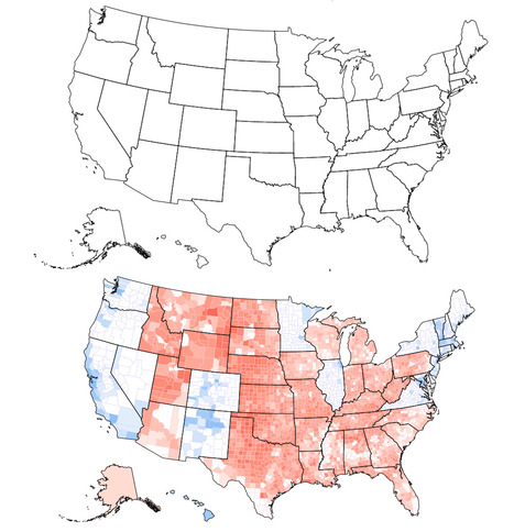
Clinton would have won if the United States looked like the top map

Clinton would have won if the United States looked like the top map | Human Interest | Scoop.it
Can you tell what’s wrong with this map of the United States? I’ll give you a hint: Look near the Great Lakes and the Gulf of Mexico. Spot the problem yet? A further hint: Look at the border of Wisconsin and Illinois as well as the Florida Panhandle. See it now? The Wisconsin-Illinois border is slightly more southern and the Florida Panhandle is slightly shorter.
Corey Rogers's curator insight, December 13, 2018 4:14 PM
The electoral college is such a mess that it shouldn't be relied on for figuring out the President. With the misrepresentation of the map and the continuous gerrymandering the United States should use the popular vote category instead of the Electoral College. 
Rescooped by Skuuppilehdet from Stage 4 Water in the World
Scoop.it!

Tornado Alley

Tornado Alley | Human Interest | Scoop.it
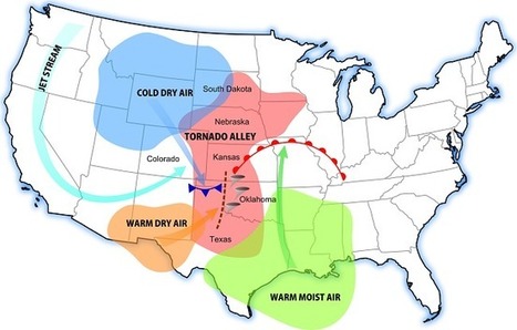
Interested in learning about tornado alley? Then you'll want to read our tornado alley facts and information. Tornado Alley 101

Via GTANSW & ACT
GTANSW & ACT's curator insight, November 16, 2016 5:35 PM

Atmospheric hazard

Luis Cesar Nunes's curator insight, November 17, 2016 5:56 AM
USA Tornado
Scooped by Skuuppilehdet
Scoop.it!

Fertility Rates-Differences Within Countries

"An important aspect about country level data of fertility to keep in mind is that there can be considerable heterogeneity within countries, which are hidden in the mean fertility which were discussed in this entry. The mean Total Fertility Rate for India in 2010 was 2.8 (UN Data): But this average hides the fact that the fertility in many Southern Indian regions was below 1.5 (which is similar to the mean fertility in many European countries), while the fertility in Northern India was still higher than 5 children per woman (which is as high as the mean of the African countries with the highest fertility)."

No comment yet.
Rescooped by Skuuppilehdet from AP HUMAN GEOGRAPHY DIGITAL STUDY: MIKE BUSARELLO
Scoop.it!

Why Ukraine needs Russia more than ever

Why Ukraine needs Russia more than ever | Human Interest | Scoop.it
As the country risks becoming a failed state, Kiev must recognise that economic survival depends on Moscow not the west

Via Mike Busarello's Digital Storybooks
othni lindor's curator insight, October 20, 2018 12:16 PM
This article talks about Ukraine's want to be independent from Russia. Ukraine spent one winter without buying gas from Russia but instead from Europe which was significantly more expensive. As much as Ukraine wants to cut ties with Russia, it will be difficult to because for a very long time, Russia has been Ukraine's main trading partner and investor. Recently, living standards in Ukraine have gotten worse. Their economy has also collapsed recently. Ukraine has been borrowing money from Russia for many years. Getting rid of that debt will take some time. The Ukrainian president has plans to end manufacturing and industry in Ukraine and instead focus on promoting investment in information technologies and agriculture. Russia’s annexation of Crimea is the main reason for the economic collapse in Ukraine. 
Stevie-Rae Wood's curator insight, October 28, 2018 3:40 PM
Its said that our most likely business partners aren't necessarily our best friends. Ukraine and Russia have been at odds with one another for many years. Ukraine wants to be completely independent from Russia meaning they want all ties severed from Russia, economically, politically etc. This is very hard for Ukraine to do because Russia has been there main trading partner and lender of money for years. So when Ukraine spent just one winter buying oil from Europe it contributed to the economy of Ukraine to fail. (The cost of gas was much higher than Russia's pricing). Ukraine has also borrowed a lot of money from Russia and this debt is going to take a very long time to pay back. For the time being Ukraine is dependent on Russia as much as they do not want to be.
Kelvis Hernandez's curator insight, November 1, 2018 10:25 AM
It's interesting to use such a leading title for this article. Whether or not all the numbers used to make their point that Ukraine should still do business with Russia are correct or misleading a fact is that Ukraine's president is allowing his own country's economy to fall out of spite. That is how tense the situation between the two countries are. Because Russia is Ukraine's major trading partner and Ukraine has attempted to cut ties with Russia, they are hurting themselves but does that mean Russia has their best interests?
 
Scooped by Skuuppilehdet
Scoop.it!

Anyone who wants to be president needs to understand these 5 maps

Anyone who wants to be president needs to understand these 5 maps | Human Interest | Scoop.it
Parag Khanna argues that these five maps are critical to understand the world we live in.


Maps shape how we see the world.  But most of the maps hanging on our walls are dangerously incomplete because they emphasize political borders rather than functional connections.

David Stiger's curator insight, September 6, 2018 9:51 PM
It is highly doubtful President Trump read anything remotely similar to this piece. The maps fully embrace the brave new world of globalized trade, politics, and cooperation - something that is at odds with "America first" chants for isolation. China appears to be ready to take the lead in this new globalized order as it focuses on massive multi-continental infrastructure projects to increase its trading capabilities. It's also interesting to think of Canada as a greater potential partner than before because of all the various connections via transportation and communication. Canada could produce a majority of our food supply as climate change dries the world over. This article is clearly saying that geopolitical change is coming and that the leadership of the U.S. would be wise to have a plan. The only part of this article that raised eyebrows was the reorganization of the United States from 50 states to 7 regions with each region centered around a major city. Essentially it sounds like seven colossal states. The idea has potential but our adversaries, like Russia, also want to see the U.S. break apart into several regions; divide and conquer is a time tested strategy. 
Rescooped by Skuuppilehdet from HMHS History
Scoop.it!

The Food Capitals of Instagram

The Food Capitals of Instagram | Human Interest | Scoop.it
Explore the popularity of some of the world’s favourite foods on Instagram. Discover Instagram’s capital of curry, which cities are big on burgers, and where pulled pork is most prolific.

Via Michael Miller
No comment yet.
Scooped by Skuuppilehdet
Scoop.it!

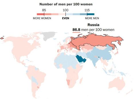
See where women outnumber men around the world (and why)

See where women outnumber men around the world (and why) | Human Interest | Scoop.it

"A new study maps the population gaps between men and women around the world."


Laura Lee Smith's comment, September 7, 2015 7:19 PM
This is actually something I discussed a while back with a friend of mine who is from Russia, how there is such a huge lack of marriageable men that women there consider being a mail order bride a good alternative to spinsterhood.
Laura Lee Smith's comment, September 7, 2015 7:19 PM
This is actually something I discussed a while back with a friend of mine who is from Russia, how there is such a huge lack of marriageable men that women there consider being a mail order bride a good alternative to spinsterhood.
Cohen Adkins's curator insight, September 8, 2015 4:59 PM

Its amazing how well balanced some countries are with the ratio of men to women how ever some of the 3rd world countries are off balance but not to an extreme.

Rescooped by Skuuppilehdet from Human Geography
Scoop.it!

Why Don’t We All Speak the Same Language?

Why Don’t We All Speak the Same Language? | Human Interest | Scoop.it
There are 7,000 languages spoken on Earth. What are the costs — and benefits — of our modern-day Tower of Babel?

Via Rebecca Cofield
Andrew Kahn's curator insight, November 4, 2017 8:13 PM
Culture speaks louder than words
 
Laurie Ruggiero's curator insight, May 29, 2018 4:48 PM
Unit 3
Scooped by Skuuppilehdet
Scoop.it!

What on Earth Is Wrong With Connecticut?

What on Earth Is Wrong With Connecticut? | Human Interest | Scoop.it
Conservatives say the state has a tax problem. Liberals say it has an inequality problem. What it really has is a city problem.


Connecticut is losing rich companies (and their tax revenues) while it’s adding low-wage workers, like personal-care aides and retail salespeople. Yet it remains a high-tax state. That’s a recipe for a budget crisis.


The rise and fall of Connecticut fits into the story of American cities. In the 1970s, American metros were suffering a terrible crime wave, and New York was dropping dead. That meant boom times for New York’s suburbs and southwestern Connecticut. But now many of those companies are moving back, lured by newly lower-crime cities and the hip urban neighborhoods where the most educated young workers increasingly want to live.


Finally, the hottest trend in American migration today is south, west, and cheap—that is, far away from Connecticut, both geographically and economically. Texas is growing rapidly, and seven of the 10 fastest-growing large metropolitan areas in 2016 were in the Carolinas and Florida. Of the 20 fastest-growing metros, none are in the northeast.


Tags: urban, regions, economic.

Mr Mac's curator insight, August 8, 2017 4:58 PM
Unit 4 - Local Politics, Unit 6 - Economic Development, Unit 7 - Urban 
Rescooped by Skuuppilehdet from AP Human Geography
Scoop.it!

Is Zealandia the eighth continent?

"A group of geologists say they've enough evidence to confirm the existence of a new continent. Writing in the journal of the Geological Society of America, the group named the eighth continent 'Zealandia.' Scientists argue for an 8th continent, Zealandia, in the Geological Society of America."


Via Courtney Barrowman
Courtney Barrowman's curator insight, April 13, 2017 10:59 AM
unit 1
David Stiger's curator insight, December 7, 2018 9:16 AM
With 94% of Zealandia lying under water, most average people around the world will not care if National Geographic prints maps with an eighth continent. As cynical as that may be, geography should not be settled by human emotions and cultural expectations. Geography is a discipline that aims for understanding and precision. If continents are to be decided by continental shelves, rather than human cultural and ethnic patterns, then Eurasia is a continent and so is Zealandia. This latter outlook of focusing on physical geography is far more neutral and scientific. I would argue that is also more 'progressive'. Humans originate from one place (Africa) and are all one species. We have far more similarities than differences. Orienting our worldview to see that cultural geography is not the final arbiter of truth would ultimately bring people together. The logic follows that by acknowledging Zealandia, there is precedent for greater accuracy based on science, allowing geographers to teach about Eurasia. This is significant because it would alter the perception that Asians and Europeans are extremely distinct and separate groups due to a distorted notion that they lived on separate continents. The truth is that both groups existed on the same continent and were often brought into contact with each other throughout history. This idea, however, would further shatter the notion of a "pure, homogeneous Europe." Europe is only a "continent" because white Europeans were the first to possess the right combination of "guns, germs, and steel" to conquer other societies and elevate their own group's cultural status. Despite nature's evidence, Europeans awarded themselves an entire continent. In reality, Europe is a large peninsula of Asia. Just as Zealandia is an eighth continent sleeping underneath the waves. 
Matt Danielson's curator insight, December 12, 2018 4:45 PM
This is interesting to think about. What decides what separates continents, is it geological barriers, is it culture, is it ethnic origin, or maybe even plate tectonics? Either way you look at it New Zealand makes a great case for why they could become to be considered the eighth continent. I could argue either way, to keep it simple and go by culture and geological commonalities (Oceania Islands) I would prefer it does not form its own continent. These geologist would argue otherwise.
Scooped by Skuuppilehdet
Scoop.it!

What are El Niño and La Niña?

What are El Niño and La Niña? | Human Interest | Scoop.it

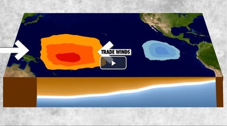
"El Niño and La Niña are complex weather patterns resulting from variations in ocean temperatures in the Equatorial Pacific--officially known as the El Niño-Southern Oscillation (ENSO) cycle. These deviations from normal surface temperatures can have large-scale impacts not only on ocean processes, but also on global weather and climate."

ROCAFORT's curator insight, February 24, 2017 2:31 AM
What are El Niño and La Niña?
Loreto Vargas's curator insight, February 24, 2017 12:45 PM
It’s a complicated phenomenon but El Niño is not the same as La Niña... Read the article.
Rescooped by Skuuppilehdet from Human Geography
Scoop.it!

Special Economic Zones

Special Economic Zones | Human Interest | Scoop.it

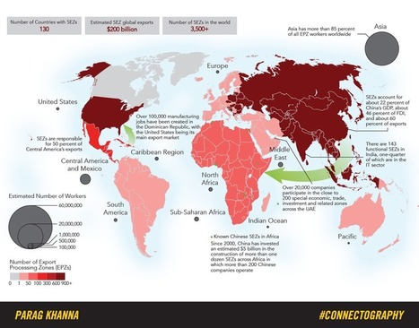
"Special Economic Zones (SEZs) are the most rapidly spreading kind of city, having catapulted exports and growth from Mauritius and the Dominican Republic to Shenzhen and Dubai -- and now across Africa. Today more than 4000 SEZs dot the planet, a major indication of our transition towards the "supply chain world" explored in Connectography.  See more maps from Connectography and order the book here."


Tags: globalization, urban, economic, industry, regions.


Via Rebecca Cofield
GTANSW & ACT's curator insight, February 6, 2017 5:09 PM

Economic activity

Courtney Barrowman's curator insight, March 13, 2017 11:32 AM
unit 6
Olivia Campanella's curator insight, December 14, 2018 8:38 PM
Thus article explains the Special Economic Zones (SEZ) are the most rapidly spreading city having exports and growth from Mauritius to the DR and now even Africa. Today more than 4000 SEZ cover the planet.
Scooped by Skuuppilehdet
Scoop.it!

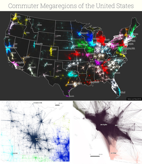
America's 'Megaregions' using Commuter Data

America's 'Megaregions' using Commuter Data | Human Interest | Scoop.it
New maps use math to define the amorphous term.
PIRatE Lab's curator insight, December 10, 2016 10:30 AM
Another example is the long line of defining the new geography.
Boris Limpopo's curator insight, December 11, 2016 1:43 AM
Le macroregioni americane con i dati del pendolarismo
Tom Cockburn's curator insight, December 13, 2016 3:53 AM
Plenty of space in the middle it seems
Scooped by Skuuppilehdet
Scoop.it!

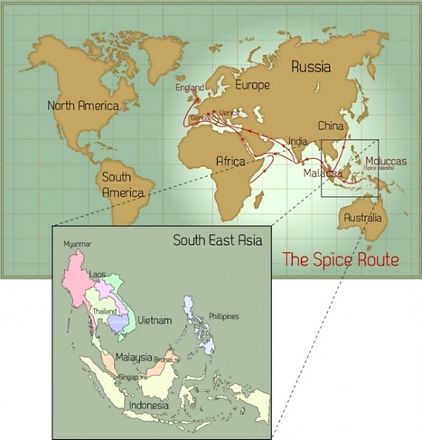
The Spice Trade's Legacy

The Spice Trade's Legacy | Human Interest | Scoop.it

"In its day, the spice trade was the world’s biggest industry. It established and destroyed empires and helped the Europeans (who were looking for alternate routes to the east) map the globe through their discovery of new continents. What was once tightly controlled by the Arabs for centuries was now available throughout Europe with the establishment of the Ocean Spice Trade route connecting Europe directly to South Asia (India) and South East Asia."

Richard Aitchison's curator insight, April 3, 2018 8:10 AM
A very insightful article and shows the uttermost importance of geography in many phases. First off, it shows the importance of  having key resources within your country or region. Southeast Asia is know for its spices which made it especially key during the age of exploration. Also, which is key is how do we get there? What are the best trade routes? Over the years, first the Romans then the Ottoman Empire controlled key lands in which connected Europe and Southeast Asia. Since, the Christian Europeans did not want to work with the Muslims  they found new trade routes and well eventually we end up discovering the New World (the Americas". This shows how everything like always connects. Southeast Asia, which for most of its time  has been colonized up until almost the mid 1980s is finally starting to grow on its own. It will be interesting to see how they use there own resources to try to gain traction in the global markets throughout the next few decades and it we see any smaller world powers come out of the area. The spice trade dominated thousands of years of trade, but Southeast Asia has many other key resources as well and it will be key for politicians and businesses in the future to capitalize on this into the future. 
Nicole Canova's curator insight, May 2, 2018 3:06 AM
It is no exaggeration to say that the spice trade shaped the world as we know it today. Southeast Asia's location made it the only place in the world to obtain some of the most popular spices and other goods. Meanwhile Constantinople, being situated squarely between Europe and Asia, was the perfect middleman through which spices could get to markets in Europe -- where demand was high from Antiquity through the Middle Ages -- until the city fell to the Ottoman Empire and turned its back on Europe. This motivated Europeans to develop the sailing and navigational technology necessary to find sea routes to Asia, which led to the discovery of the Americas, and the rest is history. What followed were centuries of colonization, conflict, trade, and globalization on a scale the world had never seen before. All because people were crazy for spices that could only be found half-way around the world.
Corey Rogers's curator insight, December 15, 2018 8:22 PM
The spice trade not only opened up all the amenities Southeast Asia had to offer but spread their culture throughout Western Europe. It also opened up new routes for Europeans to explore Eastern Asia and then sail around the world. 
Scooped by Skuuppilehdet
Scoop.it!

India watches anxiously as Chinese influence grows

India watches anxiously as Chinese influence grows | Human Interest | Scoop.it
A $46bn economic corridor through disputed territories in Kashmir is causing most concern
brielle blais's curator insight, April 1, 2018 2:41 PM
Adding infrastructure to improve trade with other countries is a strong step taken by China. This new silk road showcases how important trade is to geopolitics. Other countries are watching as this unfolds, learning and wondering what will come of it, as China continues to make economic power moves for not only it's own country but the global economy as well. 
Scooped by Skuuppilehdet
Scoop.it!

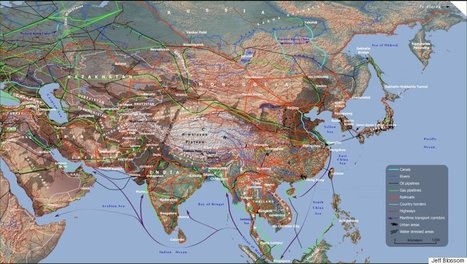
These Maps Show How Vast New Infrastructure Is Bringing the World Together

These Maps Show How Vast New Infrastructure Is Bringing the World Together | Human Interest | Scoop.it

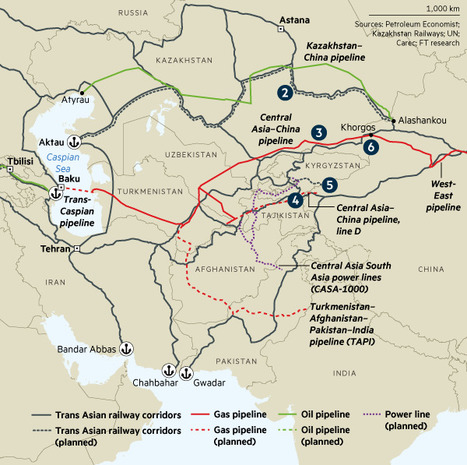
"If you want to understand the world of tomorrow, why not just look at a good map? For my (Parag Khanna) new book, Connectography, I researched every single significant cross-border infrastructure project linking countries together on every continent. I worked with the world’s leading cartography labs to literally map out what the future actually — physically — will look like.

It turns out that what most defines the emerging world is not fragmentation of countries but integration within regions. The same world that appears to be falling apart is actually coming together in much more concrete ways than today’s political maps suggest. Major world regions are forging dense infrastructural connectivity and reorienting their relations around supply chains rather than borders."


Tags: regionsmap.

No comment yet.
Scooped by Skuuppilehdet
Scoop.it!

How Islam Created Europe

How Islam Created Europe | Human Interest | Scoop.it

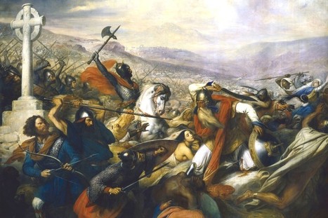
"For centuries in early and middle antiquity, Europe meant the world surrounding the Mediterranean. It included North Africa, but the swift advance of Islam across North Africa in the seventh and eighth centuries virtually extinguished Christianity there, thus severing the Mediterranean region into two civilizational halves, with the 'Middle Sea' a hard border between them rather than a unifying force. Islam is now helping to undo what it once helped to create. A classical geography is organically reasserting itself, as the forces of terrorism and human migration reunite the Mediterranean Basin, including North Africa and the Levant, with Europe." 

association concert urbain's curator insight, September 22, 2016 9:06 AM


The Atlantic

@TheAtlantic

Politics, culture, business, science, technology, health, education, global affairs, more. Tweets by @CaitlinFrazier

Washington, D.C.


theatlantic.com

Violaine Maelbrancke's curator insight, December 3, 2016 12:06 PM
Dans sa cartographie, l'Europe a souvent intégré le nord africain qu'elle a pourtant colonisé et soumis. Bien que ce nord africain ait gagné son indépendance il a conservé une relation Nord-Sud privilégiée avec l'Europe. Le terrorisme permet aujourd'hui de reconstruire une Europe bien délimitée en détruisant ce que le nord africain avait dessiné.
L'auteur critique ici une volonté européenne d'intégrer d'autres pays dont la méthode est calquée sur la méthode romaine de constitution d'un empire. L' Europe doit aujourd'hui trouver un autre moyen d'intégrer de nouveaux pays pleinement. Pour l'exemple du nord africain elle doit apprendre à pleinement intégrer l'islam en abandonnant un peu la logique législative catégorisante. Il faudrait alors construire un système où ces grandes lois deviennent des valeurs universelles qui prennent en considération les individus et leurs droits selon une hiérarchie des besoins.
David Stiger's curator insight, September 28, 2018 3:35 PM
After the fall of the Roman Empire, Europe was a disparate and disorganized collection of ethnically similar Christian tribes and kingdoms. Without Rome, there was no driving force to unify these proto-European entities. Bickering, feuding, and divisiveness dominated Christendom. 

An Islamic threat from the south, coming up through North Africa, eventually united Europeans against an "other". By sizing up to Arabic and African Muslims, Europeans saw their common ethnic and religious threads more clearly. This development culminated during the Crusades. Arguably, Islam defined and shaped the final product of Europe. 

Europe believed itself superior to the Islamic world and colonized it. Despite acknowledging the breathtaking accomplishments and advancements of their Muslim counterparts, Europeans saw themselves as something better. During the post-colonialization, 
Europe's excessive exploitation left  these old possessions in shambles without a foundation to build healthy democracies that could support human rights. Seeing itself as democratic and morally sophisticated, Europeans once again defined themselves against an Islamic backdrop.

Times are changing and Europe cannot pursue its old system of defining its civilization. Because of the geographic situation, Europe is poised to absorb the brunt of migration waves from the Islamic world. Failed states, inhumane governments, civil war, and economic collapse have propelled mass waves of North African and Arab immigrants to the shores of Europe. Cultures are mixing and the strict boundaries the old civilizations are disappearing in a more interconnected world. Europe must figure out a way to navigate these turbulent waters of change or risk giving into nationalistic extremist movements that are highly xenophobic and Islamophobic.  
Rescooped by Skuuppilehdet from AP HUMAN GEOGRAPHY DIGITAL STUDY: MIKE BUSARELLO
Scoop.it!

Can you identify these world cities from their street plans alone?

Can you identify these world cities from their street plans alone? | Human Interest | Scoop.it
We’ve stripped out the street names and lost the labels – but can you still recognise the cities from their aerial views?

Via Mike Busarello's Digital Storybooks
No comment yet.
Rescooped by Skuuppilehdet from AP HUMAN GEOGRAPHY DIGITAL STUDY: MIKE BUSARELLO
Scoop.it!

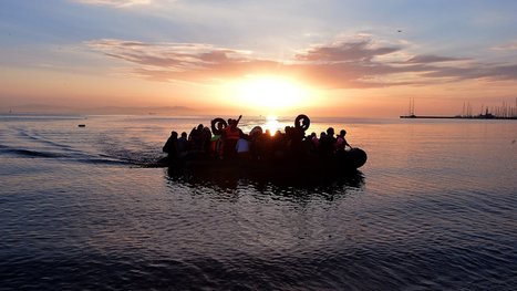
Why Are Migrants Surging Into Europe Now?

Why Are Migrants Surging Into Europe Now? | Human Interest | Scoop.it
The steady stream of migrants in past years has turned into a torrent this year. Here's a primer on the main forces at work.

Via Mike Busarello's Digital Storybooks
Chelsea Martines's curator insight, September 3, 2015 8:48 PM

There have been many many refugees that are Migrating to Europe recently. 300,000 Africans and middle easterners have gone to Morocco and then to Greece and other eastern Europe  and Mediterranean countries. These people are escaping wars and political turmoil and ripen is now having to deal with taking in all the refugees and help the families and young and old people especially that are in critical condition.

Tracy Harding's comment, September 22, 2015 10:13 AM
You provided a summary. Remember that you need a summary, global impact and personal thoughts.
Massimo Dott. For. Amb. Di Duca's comment, September 27, 2015 9:42 AM
Necessary obligation the UN